Multi-fit Design
Select the 'Multi-fit' button to create an optimized non-linear surface with slopes between the entered minimum and maximum. Multi-fit balances the dirt down the field in the direction you specify. The balancing occurs within strips, and is great for working within rows and moving minimal dirt.
• A Multi-Fit design allows the slopes to vary within set tolerances and can greatly reduce the amount of dirt moved.
• Dividing the field into regions can further decrease the dirt movement required. Enter details in the below panel and into all fields to generate a Multi-fit plane.
NOTE: If ‘min%’ or ‘max%’ are left blank the design results will not be desirable.

'Set slope range'
You can use the iGrade™ Plane Calculator to find out the average slope percentage. Alternatively you can find this in T3RRA Cutta by doing a plane of best fit in a direction and then looking at the primary and cross slopes in the plane statistics window. If in doubt, consult an irrigation engineer.
'Perform cross-strip optimization'
This will attempt to tilt the strip sections to match the actual side slope present. Use in fields that have high side slopes (>2% slope). It is unlikely to provide any benefit in relatively flat fields. (this is enabled by default)
'Perform preliminary side slope adjustment'
This will cause an initial side slope adjustment to occur. It will attempt to ensure that the side slope is no greater than the minimum row slope (use if water might have a tendency to run across rows rather than down the rows).
Cut/fill ratio, Max cut depth, & Import can be set in 2 locations. The defaults that will be applied to new projects can be set in the Project tab of settings (see section B) or in the lower left corner of the Multi-Fit (and Best-Fit) page.
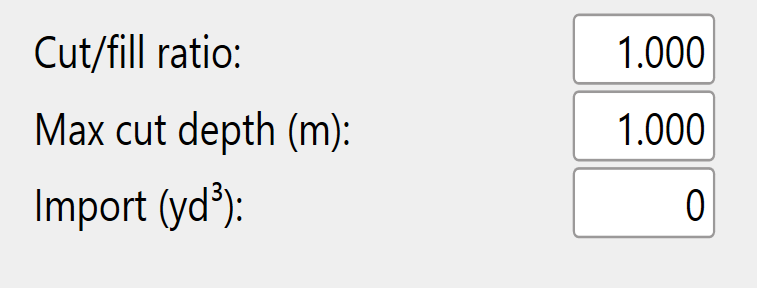
The 'Cut/fill ratio' is determined by the type of material being moved and what percentage of it will “settle” or “shrink” once compacted.
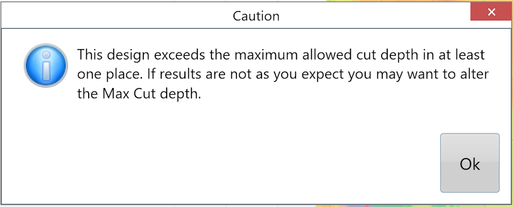
Enter a 'Max cut depth' for the maximum allowed cut depth. The following warning will appear to notify you if any points on the map exceed the max cut depth. adjustments may be required.
The 'Import' section is used when you need to bring in dirt from a stockpile or export dirt from the field to another area. Change the amount to a negative value for exporting.