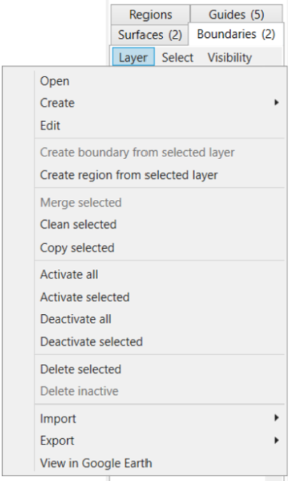
Create region from selected layer - this will draw a region around the most outer points of the selected surface and will populate a new region in the Region tab
Merge selected - (ensuring you have 2 or more boundaries selected) this will create a combined boundary, removing the initial boundaries
Clean Selected
Copy selected - this will duplicate the selected boundary
Activate all - this will activate all the boundaries so they are visible on the Working Area. This is shown by the checkbox being selected.
Activate selected - this will activate the boundary which is selected (shown by the tile having a blue highlight around it) so it is now visible on the Working Area. This is shown by the checkbox being selected.
Deactivate all - this will deactivate all boundaries
Deactivate selected - this will deactivate the boundary which you currently have selected (shown by the tile having a blue highlight around it)
Delete selected - deletes the boundary that is selected (shown by the tile having a blue highlight around it)
Delete inactive - deletes all inactive surfaces (i.e. those without a tick in the checkbox)
Import >
Import Shapefile
Import KML
Import Multiplane Boundary
Import DXF points/linework
Export >
Export selected to Shapefile
Export selected to KML
Export selected to Text Columns (CSV, TSV, etc)
View in Google Earth - this will open the selected surface in Google Earth NOTE: You must have Google Earth Pro installed on your PC for this to work.
 Open
Open